")
")

Tinh Son La Holiday Weather today
Date/time of update: July 7, 2026, 12:09 am, Timezone: GMT+7
Overcast Clouds
Temperature: 22.06°C
Temperature feels like: 22.8°C
Minimum Temperature: 22.06°C
Maximum Temperature: 22.06°C
Atmospheric pressure: 1005hPa
Humidity:95%
Visibility: 10000m
Wind speed: 1.12m/sec
Wind Direction: 285 degrees
Cloudiness: 92%
Sunrise: 2026-07-06 10:27:35
Sunset: 2026-07-07 11:49:42
It is spring time in northern Vietnam now. The official long Tet holiday has just concluded. In cities, people are flocking back for work. In the countryside, things are still slack: holidays here are normally longer! This is the time of flower blossoms and village festivals. The temperatures in Hanoi are around 20-25 Degrees Celsius. It is breezy, dry and sunshine every day.
Adventure Travel Guide to Motorbike Tours to Son La, Northwest of Vietnam
For long, I have promised to myself to have some easy time getting lost in the festive atmosphere of the North West and the trip was delayed from one year to another for some reasons. My life is passing and I don't want to waste another year!
Leaving Hanoi late in the morning, I make my way through busy traffic out of the city. Once on the familiar Route 6, things are easier. The fresh air of the green countryside around is so lovely. When you have traveled on a road many times, you don't get busy taking photos every now and again. I ride relaxingly being absorbed in the landscape along the way.

Fish broth for lunch at Hoa Binh
Arriving at Hoa Binh City at lunch time, I pull in my favorite restaurant by the side of the Da River. It is not busy today; people are still having a Tet holiday here. I take a table in the back where I can get a nice view of the river and get some breeze. Further to the horizon, the mountains are still covered in thin mist. The scene is so peaceful and bucolic.

The Da River in Hoa Binh, view from the restaurant
From Hoa Binh City, the road goes up all the way to Mai Chau. While the elevation of the area is higher, it is hot and dry due to the wind from Laos. It has to be 33-35 Degrees Celsius here today, much warmer than in Hanoi. Local people say the temperatures drop down to around 20-25 Degrees Celsius at night though. There are a lot of orange plantations and orange fruit stalls by the road side. It is in season now.

Mai Chau Town
The altitude changes suddenly and the air gets much cooler. I realize to be climbing the high pass of Thung Khe. The view of the mountains down below the valley is so sublime. The sunshine seems softer than earlier. It is wet and foggy on the peak of the pass as usual. It is amazing that even when I'm down at the base of the pass now that the air is very pleasant. It was hot on the other side of the pass. The breeze makes it even nicer! Down below, I could have a great view of Mai Chau Valley in the haze. I had several trekking adventures through different ethnic villages in Mai Chau earlier.

Old Route 6 to Moc Chau, Son La
The road goes up all the way from Mai Chau to Moc Chau Plateau. The plateau has the average altitude of over 1,000m above sea level with cool climate all year round. The favorable climate at Moc Chau makes it a great place for growing green vegetables, green tea, raising cows for meat and for milk. Moc Chau is quickly being turned into a tourist destination nowadays. There are various ethnic minorities in Moc Chau that visitors can spend a night at their family to get an experience. You can go for mountain climbing, leisurely cycling or mountain-biking at Moc Chau... AdventureGreen is proactive in sustainable tourism and we have different green trips and adventure tours around the plateau.

Houses by the old Route 6
At Long Luong Coummune, I turn into the old Route 6. The new Route 6 now is in excellent condition and the landscape along the road is very beautiful, but I have been on it several times already. The old one is mostly used by local people nowadays. It is not well looked after, but the condition is fair and it is quiet. It is great to be on the road by yourself with high mountains on one side and with valleys and mountains down below you on the other. On the old route, I can have great views of mountain peaks all the way to the horizon.

Mountains at Moc Chau, Son La
The town of the former Moc Chau Farm welcomes me with vast green tea plantations. It is late in the afternoon, the sunlight is soft and the temperature is so pleasant. I have to stop every now and again amid the green tea plantations to take in the beautiful atmosphere around. It is so refreshing!

Tea plantations at Moc Chau, Son La
The day seems to be passing quickly and I continue my journey toward the center of the town and pull in my favorite hotel. They have a room for me with beautiful views of the mountains in the back and in the front. The receptionist gets me a flask of hot water which I could make refreshing hot tea. It is lovely to relax in the room adoring the beautiful nature around...

Hotel room at Moc Chau, Son La
I get up early in the morning and proceed to the restaurant for breakfast. I love the fresh milk which is provided to the hotel by local farms. It doesn't taste that nice this time though. Maybe I'm feeling a bit tired today. It's good to make it quick and start early then. It is a beautiful day with dry and clear sky, and with pleasant temperature.

Mountains at Yen Chau, Son La
The road out of Moc Chau Town is mostly downhill and the first leg of the road is on the brim of a beautiful valley. Down below I can see tiny villages and rice fields. The haze is lifting up and it's definitely going to be a sunny day. The scenery by the road side changes quickly at Yen Chau District. It is getting warmer and drier here. It looks it doesn't rain in the region for some time; the trees show withered leaves.

Scenery by Route 6 at Yen Chau, Son La
I know that some provinces in the North West of Vietnam have a different weather pattern compared to the rest of the north of the country. From February through April, this region is affected by the dry and hot wind from Laos. While it may be drizzling, cold, wet and foggy in the Red River Delta; it is just sizzling hot in some places here.
 A valley at Yen Chau, Son La
From Yen Chau to Son La, the road is basically flat. The terrain includes low mountains and some vast stretches of idyllic valleys. It gets very hot when I reach the road junction of Co Noi. From here, there are Route 133 and Route 37 to Yen Bai, route 6 to Son La City. The road junction of Co Noi and the routes which converge here were targets of heavy bombardments by the French during the Dien Bien Phu Battle.
There is not much for me to see around Co Noi, I only take a photo of the War Monument, then continue to journey towards Son La City. It is very dry and very hot here today. It is about mid day when I reach Na San. This site was one of the strongholds of the French in the North West of Vietnam during the First Indochina War.
 Na San Airfield
Na San was where the French organized fire points of a camp into a tactic called hedgehog. The hedgehog at Na San caused difficulties to the Viet Minh in a battle in late 1952. Na San Battle brought confidence to the French that the hedgehog is the effective defense model to cope with Viet Minh's attacks in the mountains. With the confidence, the French turned Dien Bien Phu, a very strategic position, into a hedgehog of much larger scale than that at Na San.
On the other side, the Viet Minh learned from the unsuccessful attacks at Na San. General Giap was glad that the French made another challenge at Dien Bien Phu with a hedgehog. In his memoir later, General Giap recalled that on the way to the front for the battle he was so keen to know if Henri Navarre's challenge was a real one!
 Route 6 by Na San Airfield
I walk about the airfield of Na San and take photos of the surrounding hills then take off for Son La City. It is getting too hot here. It is over mid day when I reach Son La City. The heat is like in a bakery now that I think it is better to travel further to Mong Village where I could get good food and relaxing time at the hot spring. The road is very dusty and my interests seem to subside a bit. The scenery by the roadside is very beautiful though....
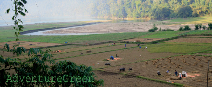
 Countryside outside of Son La City
After a while I struggle my way to the village starving with a roaring stomach. Things have changed so much from my last time here. The houses are now very crowded and families build baths for visitors to dip in the water taken from the hot-spring. All looks just so shabby and dusty that I decide to turn around immediately.
Arriving back at the city, I pull into a noodle soup restaurant and get one with beef, then rush to the hotel. It has been a hot and tiring day, and it is so wonderful to get into the room with refreshing air-conditioning. I put myself in bed and forget about everything...
 The former prison of Son La
Waking up when it is nearly 4P.M, I get the camera and ride around for a glimpse of the city. It is much more developed now than my last trip here. The mountain town is gone now and replaced by a huge city with lots of new roads and lot of traffic. The local economy clearly benefits a great deal from Son La Hydro-power Plant and agriculture...
After visiting the gruesome former Son La prison which is turned into a museum nowadays, I head out of the city to get some fresh air of the countryside. Thai villages here are very well organized and have a prosperous look. All is very clean and the road is excellent, this is in stark contrast to the village I came earlier. Graceful Thai ladies are still at work in their rose fields. It is late now and the sunlight is getting weaker. The atmosphere is so peaceful and idyllic.... I'm lost in time for a moment then get on my motorbike for the trip back to the city. It is not that bad a day after all!
 Rose fields on the outskirt of Son La City
I wake up early in the morning after an easy evening and a good sleep. It is just quiet all around and it's so lovely lying in bed doing nothing. When glary lights shine through the opening between the curtains, it is time to get rolling...
After a quick shower and check-out, I'm back on the road again. The city is still quiet and it is a chilly and fresh morning. Breakfast with vermicelli and grilled pork is not that impressive, but it helps me with the long journey today. The road out of Son La goes up slightly. I stop and have a photo of the city amid mountains. The mist is lifting up and the sun is rising.
 Mountains just outside of Son La City
The landscape today is so sublime with forests, ravines and imposing mountains by the roadsides. The elevation seems much higher here than back at Son La that it is freezing cold. I have to stop and put on more warm clothes to continue the journey.
While I am absorbed in the breathtaking scenery, there's a gathering like a festival in the front. It's a small Thai community and they are celebrating the Lunar New Year still. The ladies look so charming in their traditional costumes! I'm sure after the performances, there will be a lot of other activities going on. They all will have a great drinking time! The sun rises quickly and the temperature gets a bit warmer, it is wise to hit the road again. The lighting is just wonderful for photos of the scenery on the way, especially that on the Pha Din Pass.
 A Black Thai dance at Tong Lanh, Thuan Chau District
 Coffee plantations at Thuan Chau
The road further is through coffee plantations, dry terraces and more and more mountains. After an hour, I find myself climbing the Pass of Pha Din. In the local Thai language the pass name means the Pass of Heaven and Earth. It is 32km long and over 1,000m in elevation. The further I climb the pass the more serrated mountain peaks are seen. The landscape is wonderful, especially when it is blue sky, dry and fresh air like today!
 Mountains at Pha Din Pass
I stop near the top of the pass to take in the fresh air and the surreal landscape around. It is just so relaxing. There are two young men riding 2 scooters and they are having a break like me. We have a brief conversation through which I know that they are from Son La Province. They had a trip to Mu Cang Chai to visit their girls via a different road and are coming back via this way. It is their first time traveling on the pass and they also like the scenery here a lot. They are young, genuine and so friendly. I am really impressed by their love and their sincerity. I bid farewell to them wishing them all the best. My adventure continues further on the Pha Din Pass into Dien Bien.