")
")

Tinh Cao Bang Holiday Weather today
Date/time of update: August 3, 2026, 1:27 am, Timezone: GMT+7
Overcast Clouds
Temperature: 24.14°C
Temperature feels like: 25.06°C
Minimum Temperature: 24.14°C
Maximum Temperature: 24.14°C
Atmospheric pressure: 1007hPa
Humidity:94%
Visibility: 10000m
Wind speed: 0.58m/sec
Wind Direction: 89 degrees
Cloudiness: 100%
Sunrise: 2026-08-02 10:27:55
Sunset: 2026-08-03 11:36:27
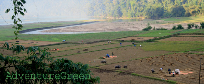
On this motorbike adventure, I enter Cao Bang via Meo Vac, Ha Giang. For most of the morning, I followed the Nhiem River downhill through peaceful countryside and sublime mountains toward Cao Bang. At Niem Tong (Meo Vac, Ha Giang) and Ly Bon (Bao Lam, Cao Bang) the Nhiem River joins the Nho Que River to rinse the water into the Gam River.
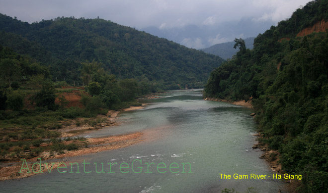
The Gam River, Cao Bang
Adventure Travel Guide to Cao Bang by Motorbike
The road in Cao Bang is basically flat and from Bao Lam to Bao Lac District it travels by the Gam River all the way to Bao Lac Town. The mountains in this part of Cao Bang Province are idyllic and it seems they are covered by more trees than in Meo Vac.

The Ly Bon Bridge, Bao Lam, Cao Bang

Road junction at Bao Lam
Passing the Ly Bon Bridge, there is a road intersection with one branch goes to Ha Giang City and the other goes to Cao Bang City. I take the latter one and travel to Bao Lac Township. The township is small with a few streets and clusters of houses. There is a lot of construction going here with new roads and new houses. They seem to have a plan for expanding it.

Bao Lac Market
The Central Market at Bao Lac is by the riverside and I had a good time at a riverside restaurant behind the market. Things don't look that attractive now that I go back to the outskirt of the town for lunch at a small restaurant. The owners are a young couple and their guests are local teachers and governmental employees. They only serve fried rice and I ask for one. The food comes out quick and looks tempting, but not good at all. The rice was not well cooked really. It is a long and bad road in the afternoon through a poor region which has virtually no visitors. I think I had better make an effort to consume it all.

Lunch at Bao Lac
The hot broth helps me to finish lunch and hurry out of the restaurant back to the town. There is a small road in front of the market which travels close to the Chinese border to Thong Nong and Ha Quang Districts. This is the one I am taking this afternoon to Cao Bang City. From Bao Lac Township, there is another road which goes to Cao Bang City via Nguyen Binh District that I did on my last trip. It is in the early afternoon and there is nobody else on the small road. Here I'm alone with the mountains and fresh nature. It rained some time earlier that the road sides look wet. The air is dry and chilly and I'm feeling excited to venture into the new area again...

Road from Bao Lac to Xuan Truong
The road goes up slightly as I come into Khanh Xuan Commune. On the way, I can see patches of denses forests, myriad terraces and scattered ethnic communities on the mountain sides. The scenic landscape sometimes has a menacing look with deep ravines and mountain gorges. It is strange that the road is good but there is virtually no traffic and I don't even see anyone around.

Mountains at Khanh Xuan, Bao Lac, Cao Bang

Mountains at Khanh Xuan, Bao Lac, Cao Bang

Villages at Khanh Xuan, Bao Lac, Cao Bang
All of a sudden, I travel past some blind curves and the gradient goes up abruptly with vertical limestone mountains by the side. It seems that they have just broken the new path through mountains that moss hasn't had the time to grow on the rock surface just yet. The rock looks precarious that it could fall down anytime. It sends chill down my spine and I had better accelerate to get past the area as quickly as possible. It is like going around a water well from the bottom to the top. The altitude is higher up here that the air gets colder and damper, and the fog gets thicker.

Mountain road at Xuan Truong, Bao Lac, Cao Bang

Newly opened road to Xuan Truong from Bao Lac
After half an hour I come to the top of the pass and in front of me down below, there is a valley covered in thick fog. It is the valley of Xuan Truong Commune. It had been mostly separated from the outside world by high mountains all around. There should be great photo opportunities around here if the weather were nicer. There is a small but good road which travels through the valley with ethnic houses and huge farms around.

Xuan Truong Valley in the fog

Road through the valley of Xuan Truong
Leaving the valley of Xuan Truong behind, the road goes up again. For another hour or so, I have to make my way through so thick fog that I have no idea where I am. And the rain makes the road under construction just very bad. It is muddy, sticky and slippery. It is so dangerous that I don't know what is by the road side, it could be deep abyss...

Mountains at Can Nong, Thong Nong, Cao Bang
Then it goes down and things are clear again. Still, it is very cold. Now I can stop my motorbike and get my phone out to check the map. I'm in Can Nong Commune and about to enter Can Yen Commune of Thong Nong District. The Chinese border is just nearby. It is only 03:00PM but it looks as if it were getting dark soon.