")
")

Tinh Lao Cai Holiday Weather today
Date/time of update: July 28, 2026, 12:00 am, Timezone: GMT+7
Overcast Clouds
Temperature: 18.42°C
Temperature feels like: 18.93°C
Minimum Temperature: 18.42°C
Maximum Temperature: 18.42°C
Atmospheric pressure: 1007hPa
Humidity:100%
Visibility: 5659m
Wind speed: 0.9m/sec
Wind Direction: 94 degrees
Cloudiness: 100%
Sunrise: 2026-07-27 10:33:53
Sunset: 2026-07-28 11:46:53
The Ngu Chi Son Mountain is Ngu Chi Son Commune (formerly known as Ta Giang Phinh or Ta Giang Phin Commune, and Ban Khoang Commune), Sapa District, Lao Cai Province. The mountain is also on the border with Son Binh Commune, Tam Duong District, Lai Chau Province.
Travel Guide Overview for the Ngu Chi Son Mountain in Lao Cai Province
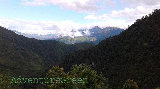
The Ngu Chi Son Mountain is 2,858m above sea level and is composed of 5 mountain peaks aligning on the axis of northwest-southeast. The name Ngu Chi Son meaning the Five-Finger Mountain comes from the shape of these peaks which look like a hand with five fingers. Ngu Chi Son is almost cloud-crested all year round.
Compared to the other high mountain peaks in the Northwest of Vietnam, scaling the summit of the Ngu Chi Son Mountain is the most difficult of all. And the mountain is the least known in Vietnam even to local ethnic communities.
Given the vertical sheer rock cliffs and steep mountainsides that one has to go through on the way to the summit, climbing the Ngu Chi Son Mountain is only for the fit and experienced mountaineers.
Weather and Climate, Best Time to Visit
There may be typhoons in Northern Vietnam between June and October; during this period it not recommended to take a trip to the Ngu Chi Son Mountain when the region is under impact of a typhoon. Normal weather patterns by month are as follows:
+ December – January: winter, dry days mostly, cold and possibly snow/frosts between 20-December and 15-January, peach and plum blossoms in January;
+ February – April: spring, dry days mostly, peach and plum blossoms in February, Rhododendron flowers in March-April;
+ May – August: summer, hot (not on high altitudes), strong sunshine, possible typhoons June-August with torrential rain;
+ September – November: autumn, pleasant temperatures, lovely weather mostly except for time under typhoon impact (4-6 typhoons/year in northern Vietnam between June-October).
What to expect on the trekking tour
The trekking distances to the summit of Ngu Chi Son include 15-20km uphill and 10km downhill. The routes depend on the season: when it rains it is not possible to take the shorter routes.
Day1: Trekking Suoi Thau Village ( from 5 to 8 hours) to the Mountain Hut
0900-1000 A.M: Start in a flat valley, then pass through barren hills, then thin forests. The first latter part of the adventure involves almost vertically steep mountain slope.
1200: Lunch in a forest with cardamom plantations at 2,400m. From here dense forest starts, it is more moist and foggy in the dense forest.
1300-1500: Dense forest with big timber trees, steep gradients.
1500: Arrive at hut.
The mountain hut is at 2,600m which could accommodate 25 persons a night. The hut offers stunning views of the valley (often filled up with an Ocean of Clouds) and mountains below.
(If you still have a lot of energy why not enjoy a magical sunset on the Ngu Chi Son Peak then?)
1500-1600: Trek from hut to summit is almost on a vertically steep cliff all the way.
1630: Descend from summit.
1730: arrive back at hut.
Day 2: Trekking from the Hut to summit again and back to hut, trek down the mountain
Plan for a couple of hours to ascend the summit again if you wish to adore the amazing sunrise from the peak of the Ngu Chi Son Mountain.
Descend from hut to the mountain base takes anywhere from 3 to 5 hours.
Where to stay
There is a shelter of 10m2 without facilities. There is a stream nearby to get water for cooking.
How to get there
From Lao Cai City we have to travel to Sapa first. This leg of the journey is 40km and the road is in great conditions.
The second leg of the adventure tour is from Sapa to Ta Giang Phinh Village which is another 25km via Route 4D (good conditions) and provincial route 155 (not so good conditions).
AdventureGreen organizes trekking and hiking tours to the Ngu Chi Son Mountain as well as other high mountain peaks in Yen Bai, Lao Cai and Lai Chau Provinces. The adventure tours range from 3-5 days from Hanoi.
Lao Cai Average Monthly Rainfalls and Temperatures


