")
")
 in Yen Bai")
The North-West of Vietnam is home to quite a lot of mountain peaks of more or less than 3,000m above sea level and most of them are untouched and free from mass tourism. And I have summited some of these high peaks.
Travel Guide to Trekking Tour to Mount Ta Chi Nhu (Phu Song Sung) Yen Bai
I had been occupied with a lot of work at the beginning of this year that my plan for climbing Ta Chi Nhu Mountain at Tram Tau, Yen Bai Province was delayed a few times. The mountain peak is 2,979m above sea level, the 6th highest mountains in Vietnam.
It was about mid April and the rainy season was just around the corner. This year the rains seemed to come earlier than usual. I got a bit nervous as I heard news of torrential rains somewhere in northern Vietnam. And I had called up my Hmong local guide in Tram Tau to update me on the weather as I was planning for the trek at the weekend.

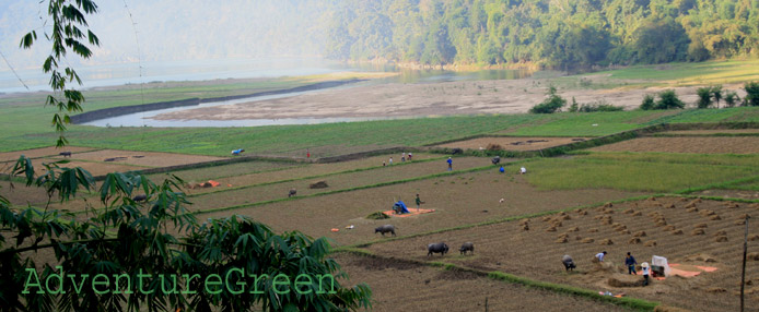
Rice terraces at Xa Ho, Tram Tau, Yen Bai, Vietnam
It was Thursday that I was having coffee and ready to depart for the trip to Yen Bai when Thanh, my Hmong guide, called me and said it was raining heavily at Tram Tau at the time.
- “It was sunny yesterday and from last night it has been raining heavily.”, said he.
- “I looked up the weather and found that it should be nice tomorrow and the day after.”, said I.
- “It looked really gloomy and I'm afraid that it may rain for the next few days”, added Thanh.
- “I'll depart now and we'll start the trek tomorrow or the day after whenever it stops raining. I may wait in Tram Tau till this weekend. Could you keep on with the preparations then?”
My trip to Tram Tau was almost a lovely experience, save for the rain in Phu Tho. It was sunny and lovely when I was at Muong Lo Valley when Thanh informed me on the phone that the sun came back. So it was good then. It was dry and breezy when I arrived at Tram Tau and I had sound sleep in the night…
Awakened for no reason at 04:15 in the morning, I clambered out of the room and looked at the sky. It was windy and lovely a night; I could go on with my adventure today then! Too happy with the prospective weather, I went back to bed and quickly went back to sleep.
I was in deep sleep when the phone rang; Thanh called me and said he was coming to town to pick me up. I looked at my phone and it was 06:14 A.M. I told him that I should be ready by 07:00 A.M. It took Thanh a while to prepare things that we could start only when it was about 08:00 A.M.

The road at Xa Ho to the Ta Chi Nhu Mountain
We made it to a lead mine at the base of the Chung Chua Nha Mountain where our trek started at 08:51 A.M. It took us 1 hour to travel 9km from Tram Tau because the landscape was great and we stopped quite a few times for photography. It suddenly turned cool and foggy when we started on the gravel road at the mine. And I was a bit worried about the weather. We'd go with the flow anyway.

The gravel road at the lead mine to the starting point for the trek
At the end of the road, we had to ascend a treacherously steep and slippery mountainside. Then came a footpath with gentle gradients. The sun came out just as suddenly as it had disappeared earlier. It was breezy and I had no difficulties with the hike.

Thanh, my Hmong guide at Ta Chi Nhu, Tram Tau, Yen Bai
It took us about 1 hour hiking on the gentle footpath. Then came steep gradients one after another without any interruption. I felt I couldn't find a place where my two feet could rest on an even surface for the whole way! It was quite disappointing looking up and found the mountain peaks were brutally high and far above. I convinced myself to stop thinking, stop looking above and to keep on hiking!

Lovely sunshine brought along hope and joy on the trek

Having a rest after the first leg of the adventure

Here came the steep slope

The summit of Ta Chi Nhu was nowhere in sight

The tiny trees on the top there mark the midway between the summit and the mountain base
Two hours and a half later, Thanh suddenly led me into a dense forest area with a vertically steep path. He said it was a short cut which was much steeper than the normal route. There were no leaning points and no trees or vines that I could cling to going down the path. And I had over 12kg of luggage on my back! I told Thanh to help with the bags and managed to clamber down fine. On my last trip I had had problems with the slippery shoe soles that I felt down a few times and that made me feel unsure of my steps nowadays.

The secret shortcut which was by no means easier

Landslide some short time ago here
We soon arrived at a small stream with running water where Thanh said we should stop for lunch. This area was covered in dense forest while most of the mountain sides were barren; there had been forest fires some time ago here. There must have been landslides here due to recent heavy rains that the water washed away most soil from the root of a huge tree where I was sitting. It looked so scary that I moved farther upstream and sat on a rock in the riverbed.

Another steep slope to climb after lunch
We made lunch quick and climbed up another steep gradient which was also created by running water and there was nothing to hold as leaning points. A short while later, came an almost vertically steep and high mountainside and I was not sure I could move upward without anything to cling to! Thanh kept convincing me that I should do it fine and that I should not fear. Again he helped me with my camera and I could climb up even to my surprise!

Here came mission impossible with the long and steep ascent!
When we were at the top of the steep mountainside, I could get some views of the surrounding mountains. Looking to my side I could see the regular route and three trees. Thanh said the three trees mark the middle of the trek between the mountain base and the summit. Well, we were over half way then. I checked the time and we had trekked for three hours and a half. Pretty good pace that I did this time! The winds were stronger and stronger as we got higher and it was half sunny and half cloudy. The weather was about perfect then; it was just that it could have been nicer with either the “ocean of clouds” or with the blue sky. But I was expecting too much then.

The rewarding view after the hard job completed

The landscape could have been nicer
The path now was still going up but not as steep as it had been back there. Yet the winds turned from bad to worse which blurred my eyesight. Holding my smart phone to take photographs was very difficult.

Lovely footpath meandering amid peaks
We arrived at the campsite at 13:30 after trekking for four hours and a half. It was bright sunshine and extremely strong winds here. Thanh told me to leave unnecessary luggage and that we should summit immediately lest the weather might turn worse.

View from the campsite upwards where we'd ascend for the summit
The path to the summit from the campsite was steep but not as bad as earlier. Furthermore it was so beautiful scenery around that I felt much better. Still, the winds were the killer up here! Thanh had left his belongings at the campsite and helped me with my backpack. We kept on trekking upwards without any stop.

Thanh with my backpack amid lovely nature
There were no more forests up here. It was all barren hillsides and mountain peaks around. The air was so fresh and I felt refreshed in spite of the horrible winds which seemed to get worse and worse every moment. I made a mistake leaving my windproof jacket back at the campsite. I had seen lovely photos of Ta Chi Nhu with white clouds wrapping around the mountain peaks which made them look like green islands amid a white ocean. Today they showed there real appearance which still looked just impressive to me.

Some spectacular scenery on the way to the summit of Ta Chi Nhu
I kept on hiking and taking photos without asking further questions like “are we there yet”. It is normal that when we climb mountains we think the highest peak in sight is the summit but when we get there it is only a higher level from which there is a small path leading you to seemingly another peak… It goes on and on until it is the real final peak that you have conquered.

Thanh was trying to fix the stainless steel tetrahedron marker of the summit
I did not bother any more about the hike but felt very annoyed by the winds which were blowing sideways. I did blame myself again for being stupid not bringing along the windproof jacket. Holding the smart phone for photography was impossible sometimes. Up here there were many dead trees as a result of forest fires earlier.

Summit of Ta Chi Nhu, "Yes, we are there now!", at 2,979m in a lovely afternoon with extremely strong winds
At 15:45 I was so glad to see the triangular pyramid (tetrahedron) made of stainless steel which was the marker for the summit of Ta Chi Nhu Mountain. We had been trekking for almost 7 hours to get here! The name comes from local Hmong language. The mountain is Phu Song Sung (or Pu Song Sung) in local Thai language. It seems that the Hmong accounts for most of the population of Tram Tau, hence the name Ta Chi Nhu used more often.
To be continued...