")
")

Tinh Ha Giang Holiday Weather today
Date/time of update: August 3, 2026, 2:00 am, Timezone: GMT+7
Light Rain
Temperature: 27.22°C
Temperature feels like: 31.86°C
Minimum Temperature: 27.22°C
Maximum Temperature: 27.22°C
Atmospheric pressure: 1007hPa
Humidity:94%
Visibility: 10000m
Wind speed: 0.69m/sec
Wind Direction: 133 degrees
Cloudiness: 100%
Sunrise: 2026-08-02 10:31:47
Sunset: 2026-08-03 11:40:34
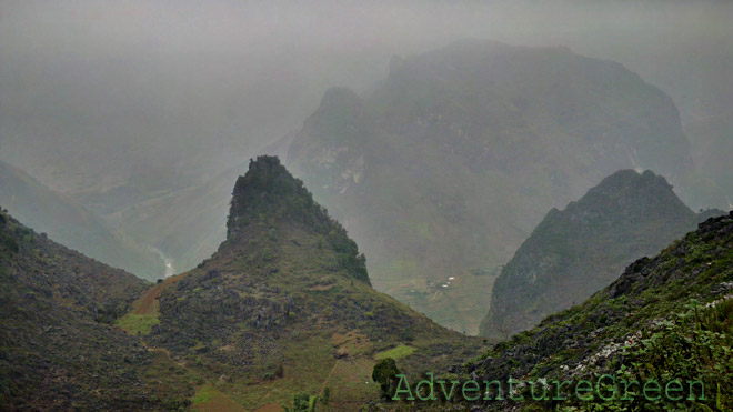
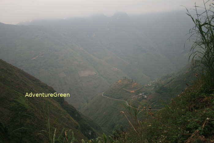
Ma Pi Leng Pass is located in Meo Vac District, in the Dong Van Plateau in Ha Giang Province. The pass is 15km southeast of the Dong Van Old Quarter, 170km northeast of Ha Giang provincial capital city.
Travel Guide Overview for the Ma Pi Leng Pass, Ha Giang
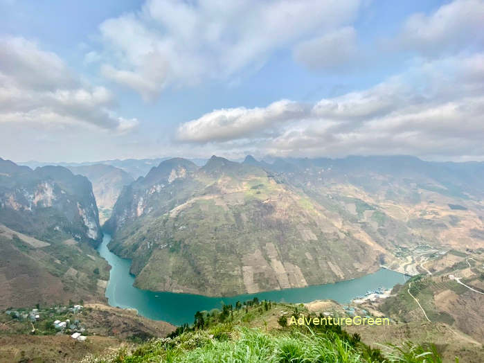
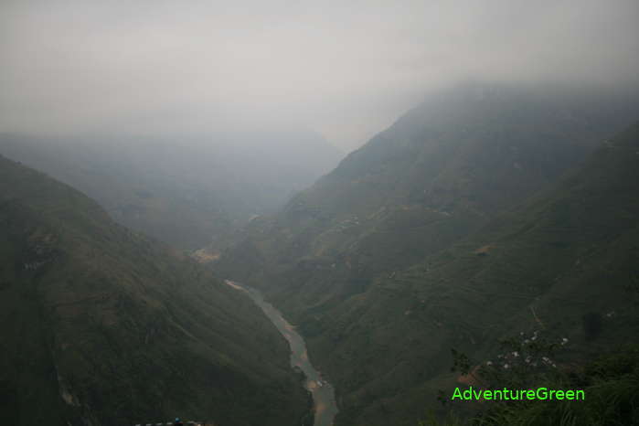
The Ma Pi Leng Pass connects Dong Van District and Meo Vac District. The pass is 20km long and is on the elevations of 1,200-1,600m above sea level. There are several high limestone mountain peaks of 2,000m around the area of the pass. And there is the Nho Que River which is 600-700m below the mountain pass. Needless to say how sublime it is the unrivaled landscape in this area!
Construction of the Road of Happiness
Before the road through the pass was built there was only a tiny and precarious broken trail by vertically steep rock cliffs linking these two locations. Passing through the mountain meant hanging oneself on the rock cliffs assisted by ropes to crawl to the other side. Fatal dangers awaited passers-by each time they had to travel to the other side of the mountain. The alternative was via a detour route which would have taken days!
Back then Dong Van and Meo Vac were two more populated areas of the vast and isolated Dong Van Karst Plateau. And it was necessary for locals to do trade. And after northern Vietnam was liberated from the French, construction of a road was in plan. There was a plan to build around along the Chinese border but was aborted and replaced by the Road of Happiness via the Ma Pi Leng Mountain or the Ma Pi Leng Pass nowadays.
In 1959, the road project - the Ma Pi Leng Pass was kick-started and the work was completed in 1965. During this time 1,300 volunteers from 8 provinces in northern Vietnam and over 1,000 workers from 16 ethnic groups in the northern mountains were mobilized to work on this mountain pass.
The construction of the Ma Pi Leng Pass was mostly done manually. The workers used simple tools like crowbars, shovels, hoes, spades… for their daily work. The most important and difficult part of the jobs was to plant explosive charges into the rock cliffs. And 17 young men volunteered to hang themselves onto the rock cliffs and carved into the rock using chisels so that they could put an explosive charge into. After each explosion, only a tiny piece of rock was blown away, and they had to make a tiny trail first so that it could be expanded further into a trail for pedestrians and horses, and later into road that cars could travel on!
Travel Guide, What to see, Things to do
1/ The Tu San Canyon
The Tu San Canyon stretches for 1.7km with rock-cliffs of 700-900m high at the base of the Ma Pi Leng Pass in Meo Vac District, Ha Giang. The bottom of the canyon is the Nho Que River.
To visit the Tu San Canyon you have 2 options: taking a motorbike trip of 8km each way or trekking on steep rocky path for 2km each way. Once you get to the boat pier on the Nho Que River, you can have a boat adventure to adore this amazing canyon moving up and down the river.
Near the pier is Ta Lang Village, Pai Lung Commune, Meo Vac District. The village is home to the Giay, Hmong and Tay People. The villagers maintained an isolated life before the Tu San Canyon was open to tourism.
2/ Boat Trip on the Nho Que River
A boat trip on the Nho Que River to adore the Tu San Canyon is for 20-30 minutes.
3/ Walking, Hiking, Trekking to ethnic villages
There are different trekking routes around the Ma Pi Leng Pass that you can do. The easiest routes are to visit nearby villages and the hardest one is to trek down the Nho Que River.
Some adventurers have gone as far as climbing the rock cliffs which led to nearly fatal death. The local authority has banned these activities.
AdventureGreen organizes several walking/hiking/trekking tours, mountain bike tours, and motorcycle tours through the Dong Van Plateau and Ha Giang Province.
How to get there
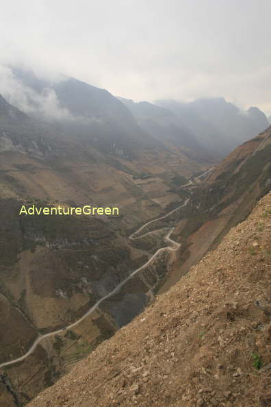
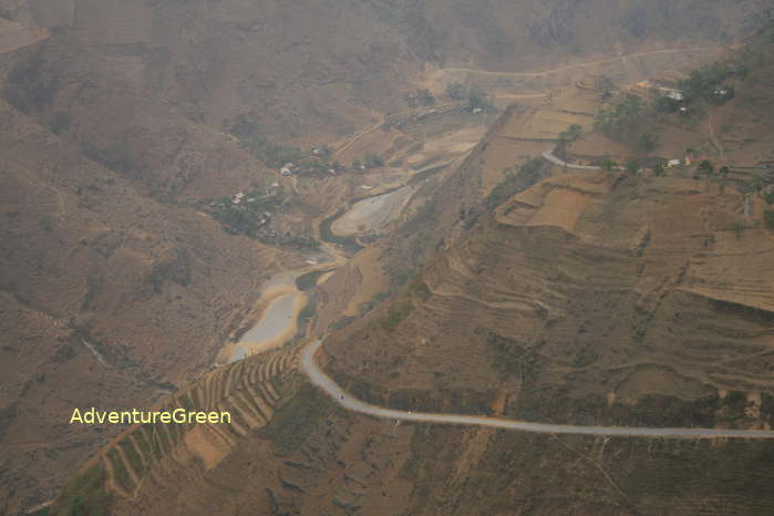
From the Dong Van Old Quarter head southeast on the Route 4C and after 15km the road starts getting up with several limestone mountain peaks all around: you are entering the Ma Pi Leng Pass, one of the most beautiful mountain passes in Vietnam.
From the Meo Vac side, after the flat and fertile land area out of town, the road starts getting uphill with a deep ravine to the right: you are climbing the Ma Pi Leng Pass with amazing scenery!
Ha Giang Average Monthly Rainfalls and Temperatures


